

Mt.Rainier Volcano:Cascades
World volcano Profiles >North America >Mt Rainier
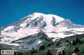 Mt Rainier is a volcano in the volcanic Cascades range of the North West USA. Anyone flying into Seattle airport will have hopefully seen the beautiful snowy volcanic cone of Mt.Rainier (4392m ;14410ft); the highest in the Cascades.The volcano and surrounding National Park are 54 miles to the south of Seattle and 100m north east of Portland.There are 26 glaciers on Rainier and you won't find a greater area of permanent ice within the USA apart from in Alaska. The volcano gives a good idea of what Mt.St.Helens must have looked like before it erupted. Mt.Rainier is likely to erupt again but at present it is asleep.
Mt.Rainier is considered to have three seperate summit peaks;Columbia Crest is the highest at 4392m (14,410ft), Point Success 14,158 ft (4315m) and Liberty Cap 14,112ft (4301m).
The Geology Bit
 Mt.Rainier is a stratocone like its dramatic neighbour Mt.St.Helens and has been around for 500,000 years. 5000 years ago it was probably 16000 ft but a huge landslide reduced the summits height and caused a mud flow which reached "Seattle". It has two summit craters over 300m across and a ice capped crater lake.
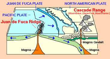
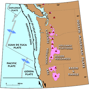
It has formed due to the subduction of the Juan da Fuca plate beneath the North American plate forming the Cascade Volcanic Range. Fluids from the subducted oceanic plate have caused melting of the the mantle wedge above the plate and this melt or magma has then risen to the surface and erupted gradually forming the cone of the volcano. It last erupted in 1894 and there are still active fumaroles at the summit which help keep the top free of ice and snow.
 The andesite rocks of the volcano have been altered by hydrothermal activity and have been described as a honeycombe.This instability combined with the significant mass of glaciers means that Rainier poses a threat lahars or mudflows to the surrounding area and Seattle itself. If an eruption occured and the glaciers melted then enormous lahars could engulf the communities near the volcano.100,000 people live on old mudflows. Evacuation plans are in place to warn and move people although how effective they would be has not been tested.
USGS Current Activity Update
What to see and How to see it?
At over 4000m high Rainier reaching the summit is not a casual stroll in flip flops! Only half of summit attempts are successful and the ascent requires specialist equipment and experience from the climber or their guide. Having said this 5000 people climb Rainier a year over 2-3 days . Most attempts start from camp Muir on the south western side. Failure is often due to poor weather and fitness.
Rainier Mountaineering Inc.(Guided climbing of Rainier)Mt.Rainier National Park Climbing Guidelines
Alpine Ascents (Guided climbing of Rainier)
Mt.Rainierblogspot (lots of info on route conditions, permits etc.)
Henry M. Jackson Visitor Centre and the Paradise sub-alpine meadows are the main destination. A new visitor centre will open in 2008 along with a refurbished Rainier lodge. The Wonderland trail is a 90 mile backpacking trail which circles Rainier and for which you must book a permit. Day walks at Paradise are beautiful with good views of the glaciers on Rainier. There are over 200 miles of trails. In Sunrise area 6400feet you can drive to 6400 ft and take the mountain trails.
Look out for bears and although its lovely to have peace and quiet - if you sit quiet and still for too long you might have company.
Flooding in November 2006 closed the park when 18 inches or rain fell in 36 hours . Some trails are still being repaired so check before you set out if your route is open. Paradise is regarded as one of the snowiest places in the world. In 1971-2 28m of snow fell during the winter.
Mt.Rainier National Park site : Plan Your visitNational Park Maps
National Park:Wonderland Trail
National Park:Day Hikes including Paradise
Bear Advice
USGS Cascades Volcanic Observatory
Webcam of Paradise
Mt.Rainier Accomodation (Paradise Inn)
Lodging Guide
American Park Network
Global volcanism project