

Mt.Tarawera volcano: New Zealand
World volcano Profiles >New Zealand>Mt Tarawera
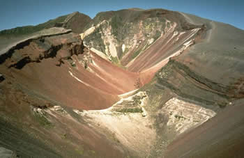 Mount Tarawera is a volcano is a small chain of rhyolitic lava domes 25km to the SE of Rotorua on New Zealands North Island. It is flat topped mountain with several lava domes.Tarawera is just one of a number of vents in the Okataina Volcanic Centre lieing between Rotorua and Kawerau. Legend says that before the 1886 a war canoe appeared to a group of tourists on Lake Tarawera and then disappeared into the mist. Local tribal leaders say it was a warning of the eruption and a reappearence will herald another eruption. Before 1886 tourists used to visit the Pink and White terraces, natural terraces of depositd silica fed by warm springs.
The Geology bit
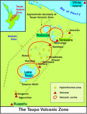
Tarawera is a series of Rhyolite lava domes within the extensional basin of the Taupo Volcanic Zone. The TVZ is an extensional basin to the east of the destructive boundary between the Australian and Pacific plates. The extension in the crust allows the upwelling of large amounts of magma under the thin crust above.The magma supplying the complex is basaltic and high in iron but low in silica in contrast the erupted lavas are high silica rhyolites.
www.teara.govt.nz:Geological Background of New ZealandVolcanoworld: Taupo Volcanic Zone
Over the past 400,000 years 6 huge eruptions have probably occured from the Okataina. A large caldera has formed as the shallow magma chamber was evacuated of material mostly in dramatic and violent explosions of pumice. The pumice lay up to 100m deepfrom each eruption in places and would have devastated large areas of North Island. Pyroclastic flows would have suged out from the eruptions. More recently smaller eruptions have followed a pattern of violent explosion followed by extrusion of rhyolite and occasionally basalt.
1886 eruption
The 1886 eruption was the largest in recorded history in New Zealand and marked a change from rhyolitic compostion to basaltic. On June 1 unusual waves appeared on Lake Tarawera and on June 10 earthquake swarms signalled the dramatic start of the eruption and within hours craters along the whole length of the moutain was ejecting ash 10km high. The eruption of basaltic scoria (shower of ejected basalt) continued along the entire length of the 17km long crater. The eruption along a fissure was probably due to extension in the crust literally pulling the crust apart and letting the basaltic magma well up. 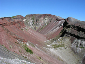
The explosions at Rotomahana formed an eruption column 10km high. Violent steam explosions blew out craters and mixed with disentegrated rock to produce showers of mud and surges of mud, ash and steam. Maori settlements were obliterated, lightning flashed, fireballs set fire to forests, trees were flattened and day became night. The next eruption at Tarawera is likely to be larger and more violent lets hope its not to soon!
www.anheizen.comWhat to see and How to see it?
Climbing Tarawera
Tarawera is privatley owned and as far as I know pretty much the only way to get to the top is through a sanctioned tour. Since 2002 private access has been restricted due to thefts from cars and disrespect for the sacred aori areas of the mountain. If the rules change then park at Ash pit road car park , pay the entrance fee and taks about 2 hours to walk to the top of the crater. But at the moment organised tours are the way to go.You can travel to the summit by 4WD or helicopter and then slide down into the crater on foot before mountain biking the rest. Or you can just travel up and down by jeep. Walking does'nt seem to be encouraged. This may not be the peaceful natural experience you were hoping for but if you've got money and want adrenalin adventure then you'll love it.
Recommended sites
www.peakbagging.co.nz for walking on Mt_Tarawerawww.mt-tarawera.co.nz: Tours and adventures
www.laketarawera.co.nz
www.helipro.co.nz: Helicopter flyover
Lake Tarawera Scenic Reserve
Lake Tarawera Scenic Reserve
Lake Tarawera Scenic Reserve lies 18km to the south of Rotorura and has plenty of walking tracks to give you a more natural and peaceful experience of the Tarawera area. The lake drains eastwards over Tarawera falls. Vehicle access to the falls is via permit along forest roads but you can walk in. Camping is allowed at a few sites eg. Tarawera Outlet and Hot Water beach.
Tarawera Falls TrackTarawera Outlet to Humphries Bay
Tarawera Outlet to Falls Track
Hot Water Beach
Just what it says! Hot Springs bubble up through the sand and give a lovley thermal bath. Accessible by boat only. On the North arm of the lake.