

Southern Iceland Volcanoes
Southern Iceland is home to the Vatnajokull glacier, Grimsvotn volcano, the Laki crater rift , Eldgja the "fire gorge" and one of Icelands most famous volcanoes , Hekla. All the features here lie in the Eastern Rift zone of the Mid-Atlantic Ridge.
 Iceland lies just beneath the Arctic circle in the North Atlantic and is often called the "Land of Ice and Fire". This name comes from a the combination of 130 volcanic mountains, hydrothermal fields and extensive glaciers the largest of which is the Vatnajokull Glacier.
The interior roads of Iceland are largely unpaved rocky tracks which a 4WD will cope with, a normal car will certainly struggle and may not cope with river crossings. Take a 4WD , a good map and ask for advice .Don't get stuck!
Driving in Iceland
An offroaders heaven! The main road around the perimeter of Iceland is paved but the interior roads are rough rock and gravel tracks and will involve river crossings so experience of 4WD , a map and of course a 4WD are essential. Make sure the petrol tank is full as petrol staions can be few and far between and non existent in the interior. Mountain Roads can be closed until June and those roads with an F prefix are only passable with a four wheel drive.The sign Malbik Endar means the paved road is about to run out - so slow down. Some river crossings can have water 4ft deep. </>
The Geology bit
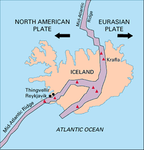 Icelands volcanoes owe their origin to the combination of two geological forces. Firstly Iceland sits upon the Mid-Atlantic Ridge, this where the North American plate and the European plate are being pulled apart at about 5cm/year. As the Atlantic gets wider magma wells up from the mantle below creating new oceanic crust below the sea surface and new land above. The Mid-Atlantic ridge extends all the way to the South Atlantic as a narrow zone of spreading,rifting and volcanic activity on the ocean floor.
Secondly,Iceland rises above the sea due to an extra concentrated jet or pulse of magma called a hot spot or mantle plume which provides an extra boost of molten rock.
The rocks erupted are similar to Hawaii in that they are mainly basaltic and produce lava fountains and flows.Iceland has extensive Geothermal activity and is home to the original Geyser. Geothermal activity also provides home with hot water and electricity.
All over Iceland you will see columnar basalt columns. These polygonal sided columns form naturally as flood basalts cool and contract. Fartifoss waterfall is a good example of these.
Icelands volcanic regions of current activity are governed by the Mid Atlantic ridge which splits the country in two. Iceland deserves its own website to do it justice so here I have just given the volcanic highlights but rest assured there are many more things to see than just the big names.
What to see and How to see it?
Lakagigar Craters / Laki 1783
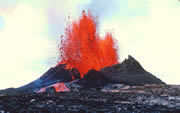
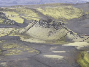 On the 8 June 1783 a fissure with 130 craters opened and continued for 8 months and expelled 15km3 of lava, lava fountains up to 1400m high and vast quantities of sulphur dioxide. The ruption produced the largest volume of lava in recorded history.Grimsvotn volcano also erupted 120 million tonnes of sulphur dioxide. The eruptions had wide reaching consequences across Europe and North America due to the cooling affect of the sulphur on the climate and a poisonous sulphurous haze which affected western Europe. An estimated 23,000 British people died from poisoning. It is also thought that crop failures and food shortages in France and New England precipiated the respective revolutions.
The craters lie 40km away from Kirkjubaejarklauster from where you can get a tour bus for the day or they can pick you up the next day if you wan to camp. The "road" is passable after July but is very rough with river crossings. Laki (818m) can be climbed from the car park in under an hour. A two hour walk south will bring you to crater with a lake in it. There are also lava caves and tubes. Kirkjubaejarklauster has tourist office,hotel,petrol station,supermarket and banks.
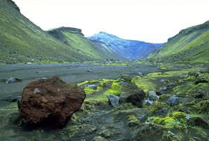 To the west of the Laki craters lies Eldgja the "fire gorge" which last erupted in 935AD . It is a volcanic rift which stretches for 40km from the peak Gjatindur southwards to the Myrdalsjokull glacier. It is possible to get dropped off to climb Gjatindur then head down into the gorge which is flat bottomed . The gorge is 200m deep and 600m wide and a fiery red colour.The Ofaerufoss waterfall is worth seeing too. Which is a 2km walk from the main Eldgja carpark.
Grimsvotn 1996
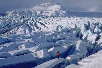
Grimsvotn lies beneath the North Western edge of the Vatnajokull Glacier. Vast subglacial lakes cover the volcano. The volcano has given us the wonderful word "jokulhlaups " which means glacier burst. In 1996 Grimsvotn erupted beneath the glacier and melted enough of the overlaying ice to lift the glacier upwards allowing an enormous flood to burst from the glacier. The main ring road was breached but thankfully no one was hurt. 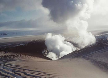 Its pretty diificult to see Grimsvotn, after all it is hidden under a glacier, but you can imagine its power by visiting Skaftafell National Park on the southern edge of the Vatnajokull Glacier. The "Sandur " which spreads out before the glacier is the result of the glacier bursts or jokulhlaups which flood the coastal plain with water ,ice and rocks. The flat grey plain is bleak and dramatic and the main road cuts right through it. Within the park there are numerous walks one of the easiest being to Svartifoss, where a waterfall ralls over perfect basaltic columns- great photo! More information on the park and the jokulhlaups can be picked up at the Park Headquarters and camping ground just off the main road. There is a film about the jokulhlaups.
Hekla
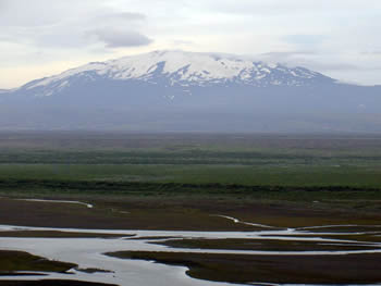 Hekla (1491m) is Icelands most active volcano and erupts every 10-30 years. Its eruptions can be dramatic and explosive rather than gently effusive and its layers of ash and lava make it more of a stratovolcano rather than a shield. Hekla sits on top of a 40km long and 7km wide fissure. It is a long thin mountain with steeper sides; a bit like an upturned boat. An active fault system allows the regular injection of magma which keeps Hekla alive. Hekla can erupt in Plinain style and ejetc vast quantites of ash over large distqances. In AD1104 an eruption covered every within 50km under a metre of ash. In 1947 an ash cloud from hekla reached Finland. Rhyolites are often the first lavas to be erupted and are very high in silica unlike the noraml Icealandic basalts. It is thought that the magma stored under ground separates in a magma chamber as it cools allowing the lighter silica minerals such as quartz to float to the top and hence be erupted first.
Hekla is often shrouded in cloud so seeing it may be difficult so try the Visitor centre at Bruarlundi near Leirubakki. Climbing Hekla requires the proper equipment and clothing and is quite a mountain to climb with glaciers and crevasses on the top. The NE route is the easiest and starts at Skjaldbreid Hill on the Llandmannaleio dirt road 8KM eastwards of the main road.
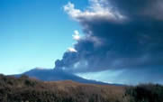
1991 : January 17 a Plinian column 12 km into the atmosphere. Fire fountains estimated to have been 300m were produced.2000: February 26 a fissure 7km opened up with a curtain of fire and an eruption column 11km high.
Landmannalaugar
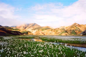 Landmannalaugar lies 600m above sea level within the Fjallabak National Park and is the place to come if you feel like a change from endless black lava flows. The volcanic rock type is Rhyolite and the landscape is a multicoloured spectrum of reds, oranges,yellows and green. The area is the biggest Geothermal field in Iceland outside the Grimsvotn caldera. The source of the activity comes from the Tafajokull caldera 10km to the SE which last erupted in 1480.
There are spectacular walks and natural thermal springs to bathe in. One of the most popular walks is the 4 day trek from Landmannalauger to Porsmork which rivals the famous Milford Track and Inca Trail for spectacular scenery. The hot spring pool, near the Lanmannaluager hut is well worth it. Access to the area is along rough tracks with river crossings so experience and a 4WD is essential.
